Showing posts with label Hiking. Show all posts

Sunday, March 2, 2014

PCT Hike Plan V2

I have finally finished updating my planning spreadsheet, and it's ready to be released upon the world. I know most thru-hikers already have their plan laid out for them (the ones that plan ahead, anyway), but I still think this is a nice and flexible tool to use before and during your hike, to try and estimate how many days of food are needed between resupplies, and difficulties along the trail.

For starters, I updated all the distances and elevation gains to use Halfmile's 2014 data. I would like to thank both Lon Cooper and David Lippke for sharing their data with me so generously, and answering my constant nagging regarding the best way to calculate different values for my tables. I also blatantly copied some data from their trail notes, with their permission.

Basically, I took my original plan spreadsheet, and normalized the table into three different ones. What it means is that the first sheet of the new spreadsheet (called "Mile Points") now contains exit points along the trail, where you can walk or hitch a ride to a resupply store or post office. Each such mile point has its distance from the Mexican border (I guess southbounders should subtract that number from 2669 to get their mileage), and cumulative elevation gain from there as well (ignoring elevation loss).

The second sheet of the spreadsheet (called "Resupply Points") lists all the different stores, towns and resorts hikers usually go to, along the trail. Each such place also contains the description copied from Halfmile's trail notes, 2014 edition.

These two sheets are mostly "static" - they shouldn't change much when planning your hike, unless some info needs updating, or mileage is changed. But they contain the basic data that the entire plan is based upon.

The third sheet (called "Stops") is where most of the action is. Over here, each "mile point" is paired with a "resupply point", which means that on a specific location (Interstate Highway 5, for example), you can exit to several different supply points (Castella, Dunsmuir or Mt. Shasta City), and vice versa. In each such section, there might be some extra walking to be done, and/or some hitch hiking needed as well, before you reach the actual resupply point. On that sheet's final column, you can mark "true" in every place you want to resupply. Leave that column empty to skip that resupply point completely.

Now you can move over to the final sheet ("Final Plan"), which will show you all the info for your planned hike, including start and stop locations for each section, resupply locations at section's end, total distance (including extra walking off trail) and total elevation gain.

In this sheet you should put in your expected hiking pace (mph), how many hours of hiking you intend to do each day, and the penalty of elevation gain on your speed (extra minutes for each 1000'). By default, each section uses the same values as the previous section. But if along the trail you start hiking faster, or longer, any change made on a specific section would immediately reflect on all following sections as well.

Another thing to update would be your start date, or the date when you intend to start hiking form the Mexican border. Again - all subsequent sections' start dates depend on the previous section's end date. But if you add a day to some start date up the trail, for taking a zero, it will also update all the next sections by the same amount. Easy. The dates will also be painted in red if they fall on a Sunday or Saturday, so you can know in advance when your plan puts you in a town while the PO is closed.

The final plan also shows the resupply point's description, for easily see what options it contain.

So - here is the link. Just follow it, and then click on File->Make a copy... to create an editable copy of that spreadsheet in your own Google Drive. Currently, the spreadsheet will not export well to Excel, but it can be easily fixed, if there is a demand for it.

Share and enjoy, and feel free to comment, ask questions, and drop a line.

Wednesday, January 1, 2014

Cooking Test

Several days ago I had a chance to try out cooking my meal "trail style", using my Caldera Keg-F Stove System and a Knorr dinner bag. I know it's not exactly like cooking on the trail, but I want to feel confident I use the proper amount of alcohol and water, and get a satisfying meal at the end.
Caldera Keg (with a spare keg), fuel bottle, spork and lighter, and the meal I'm going to eat
For this test, I used just about 20ml of alcohol in the stove. I put in a bit too much water in the keg, so for the next attempt I'll put less. Those 20ml burned for about 8 minutes, though I got a boil at around 7. So again - a bit less fuel will also work for me.
The stove inside the Caldera Cone
After the boil, I poured most of the water inside the Knorr bag (Rice with Mujadarrah), and let it sit for 10 minutes.
Waiting for the rice to cook, while watching "Alone in the Wild" on TV
I think the 10 minute mark for cooking the rice in the bag is good. The rice was completely cooked. Maybe even a bit less time would work, but unless I'm starving I don't think It'd matter much. After the rice is done, I poured in about 1/2 a bag of powdered mashed potatoes, to turn it from a soupy rice meal, into a chunky potato/rice mix. It doesn't look too tasty, but I kinda like it, and it definitely filled me up, and got me warm inside.
Yum yum. It looks oh so inviting.
I already imagine myself wolfing down one of those inside my tent, sitting under my quilt.

Oh - and a happy new year to you all. The year of my Pacific Crest Trail Hike.

Saturday, December 21, 2013

Solar Power

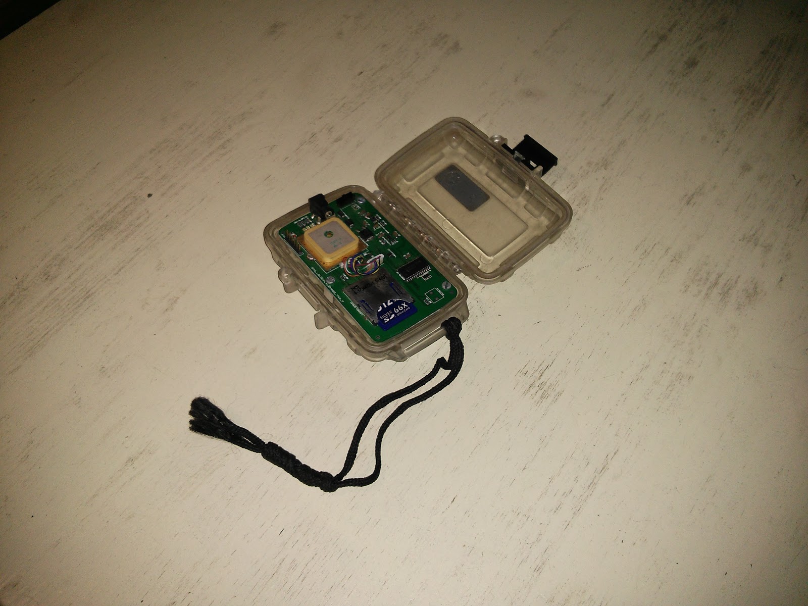
I have started looking into solar panels back around 2007, while following Craig Stanton's blog of hiking the PCT. I really liked the fact he was using a GPS to log the trail while he was hiking it, mostly because I am really into mapping. He was using an OHararp LLC GPSlogger (An older version of this) that came along with a solar panel to keep it running during the long hike.
My Geo Logger in its OtterBox case.
Before I set out to hike the Israel trail I ordered the same kind of GPS logger for myself, along with the generic solar panel. This was all in the days before smartphones, don't forget. I carried it with me while walking all the way from kibbutz Dan in the north, to Tel Lachish (Where I quit my INT hike), and photographed every trail crossing along the way, for future geo tagging of points of interest. I never did anything with the data I collected. Although I checked it out once, and the trail had sampling errors all over the place..

I later got my dad (who is an electrical technician) to fix a simple female USB connector to the solar panel, and took it with me to my hike on the GR20 in Corsica. This time I had a smartphone for the geo logging, but it stopped working on the fourth day or so. Only when I got back home I found out I managed to fry its motherboard. Oopsie. Maybe it was the improvised solar panel. Maybe it was the under clocking I'd tried applying on the phone. I don't know. After I got back home I sent the panel back to my father, for another round of checks and fixes. I noticed I couldn't get it to charge my Nexus 4 at all, and I almost gave up on the idea. But then I found a website with schematics on how to make your own smartphone solar charger. I have no idea what those schematics mean, but my father does. Another round at dad's, and I now own a solar charger that might actually work. I only received it about two weeks ago, and I haven't had any serious sunny days to try it on yet, but it does send the phone into charging mode when under sun light, so I'm optimistic. Since I do not plan on geo logging my bike this time. The charger will just have to keep the phone running occasionally to contact home, and maybe check the maps and GPS applications, if I get lost. I hope it can pull this off in between town stops. If it fails, I will probably buy the SunTactics sCharger 5 instead, since I heard a lot about it on trail forums and the Facebook group.
Getting to work by bus today, so I'll try to see if it charges my phone on the way.
Update: My test failed miserably. Even though I turned off all mobile data access during my ride to work, and did not use my phone for music or internet access, I managed to lose ~2% of battery. The panel was in the sun for most of the bus ride. I guess it is not working well...

Wednesday, December 11, 2013

Hiking Food

Well, I haven't set foot on the PCT, so I can't really tell you what I will eat over there, and what "Works for me" or not, but I thought I'd share my plans, based on the experience I do have from the AT, and some other self-supported hikes I've had. In total, I guess my food choices were pretty boring on the AT. I didn't mind eating the same kinds of stuff day after day, and I just stuck to whatever kept me full at night.

For breakfast I usually had two packets of Quaker Oatmeal. The kind with powdered milk or the apple-cinnamon flavor. Being the lazy git that I am, I would never bother with boiling water for breakfast, and just pour a bit straight of cold water into the paper packet, mix it with my spork, and eat it out. You gotta be careful to get all the powder from the bottom corners, otherwise it'll stick in there until the end, and you will be left with a salty spoon of powder to finish it off. On some town stops I bought Pop Tarts instead, the frosted kinds preferably, which I had for breakfast. They don't keep to well on the trail, but I didn't mind eating the crumbles. It tastes the same.

For lunch I usually had a tortilla with chunks of cheese and pepperoni. Being a vegetarian now I will have to skip the latter. I guess I will try getting some more trail mix and nuts for some proteins. The good thing about tortillas is that they work the same when they are dried up and a bit old - just a wrap. I guess they do break more, but it is better than having a completely stiff bun or pita.

At evenings I used to cook some kind of Lipton meal (Pasta or rice, usually). Over here they have the Knorr brand name on them, and I think in the US they changed as well, but it all works. I used to just pour the packet inside my pot, add water, and cook until the fire went out (I used a simple alcohol stove, so I just had to put about the same amount of alcohol every time, and wait it out). I also added powdered mashed potatoes and tuna chunks (I used to go crazy for the aluminum wrap packages from Starkist) - like the pepperoni, no more tuna for me. Put the whole messy concoction in another tortilla, and it's quite filling.

This time I think I'll do the dinners a bit different. I'm using a Caldera Cone F-Keg system, built around a big 24.5oz Fosters can, which is a bit narrow and tall. I tried cooking in it several times, and I keep getting some burnt leftovers at the bottom. It's also not comfortable eating straight from the pot, due to it's height. So lately I've been trying to just boil water in the can (Last attempt took just under 7 minutes for 25ml of alcohol. and it burnt for 5 more), and then pour the hot water into the Knorr packet, close it carefully, and let it sit for 10 minutes. I failed miserably once, but last two attempts had a rather edible rice dinner at the end. Again, I had way too much water left inside to make it passable for a real serving of rice, but I added the powdered potato mash and ate it like a champ. It worked like a wonder in my recent desert hike. I think it'll work just fine on the trail.

During the day I usually snack on Snickers and M&Ms, even though I remember I had some Clif Bars, and sometimes Chewy bars as well. I used to have a snack every 1-2 hours, for a total of about 3-4 a day. Not good for the teeth, but it kept me going. I'll see how it works out this time. I will try carrying GORP and nuts to replace some of those candies. I will also put more effort into having fruits and vegetables while in towns, instead of just stuffing those burgers, and maybe even carry some for the first day out of town, occasionally. I'll see how that works.

Saturday, November 23, 2013

Desert Trip Conclusion

Ok, I survived the not-so-short hike.

Our hike started after a long train ride to Be'er-Sheva, and a bus ride to Tzihur Junction (on the bus to Eilat) - a total of about 4 hours on the road. We started our actual walking at 10:15. A bit on the late side. We tried convincing the bus driver to drop us off near the trailhead, but he didn't like the idea, and dropped at at the junction, so add about 2Km of road walk to our first day.
An impressive tree, near the start of our hike
After finally reaching the trailhead we started hiking northbound on the Israel National Trail. About 3 hours of 4x4 road walking later, we finally reached the Vardit Canyon, and had a blast - At the first water hole we met a small group of 4 who got there by jeep, and they enjoyed watching us trying to get across the water in one piece.

It was possible to cross over the left canyon wall, and avoid getting wet. But we heard from a southbound hiker we've met several minutes before, that there is one water hole that required proper swimming, so we figured there's no point in trying to remain dry. I just waded in carefully, trying to walk along the outskirts of the hole, and keeping my backpack above water. Yair inflated his Neo-Air mattress, and waded across with his backpack floating on top of it. A very good idea indeed.
After crossing the first water hole, Yair is inflating his mattress for his own attempt

A short climb up some metal rings later, we met THE water hole. There was no walking around that one, with cliffs along all sides, and a metal ladder at the far end. This hole was also much deeper, and indeed required proper swimming. This time we made arrangements to use the Neo-Air for all of our gear. It took some time, but at the end we both made it to the top. We were completely wet, but the backpacks weren't, so I guess it worked. The only downside was that my hiking pants got torn pretty badly when I slipped inside the water one time.
The big water hole, getting the water bottles across using the inflatable mattress
After that hole there was some more climbing up metal rings, another ladder, and more rings to finish it up. I enjoyed this section.
Yair using his mattress to keep his backpack (mostly) dry
We were aiming at Mounta Kipah camping area, but I guess it was too far away, especially after starting as late as we did, so after thinking we were further along than we actually were, and finding out we still have about 8 more Km until we get there, and 30 minutes of sunlight, we just gave up and decided to find a place to stealth camp. Luckily, we did find a very nice spot for our tents, and went to sleep early. I think we were both out by 19:00.
My gear at camp - TarpTent Rainbow, Neo-Air, ZPacks quilt and Arc-Blast
The second day started with a short hike to Barak Canyon, this time climbing down. The trail first turned north, headed down the eastern slopes of the canyon, and reached its bottom. From there it followed it down along 3 more ladders, several sections of metal rings, and a short section of sliding along a smooth rock surface (with foot grooves) while holding a rope. It was very adventurous.
Sadly, the bit after the canyon was not as exciting. It was a long ~30Km 4x4 road walk, mostly north towards Tzofar. No major climbs up nor down. The view was pretty nice most of the time, but after several Km of walking in the sun it wasn't as exciting anymore. We bumped into several groups going south - some also doing the INT in sections, and one really large group (over 50 hikers, for sure), that passed us by when we were struggling to fit under a small rock outcrop for shade, and have lunch.
Climbing down the tallest ladder in Barak Canyon
Having a peanut butter-cheese-goat cheese-cucumber bun for lunch. I later added some pesto sauce as well
For the first time ever, we actually made a navigation error and were surprised in a positive way - we kept looking for a junction with a green trail heading east, and we didn't see it, so we thought we have at least 4 more Km util Horvat Mo'aa, and 2.5Km from there to the road. It was getting late again, and our soles hurt from all that non-stop walking, when suddenly we saw Horvat Mo'aa just a short ways off. It was a very pleasent surprise. I set there in the shade, while Yair went over to check the old Nabataeans fort.
Horvat Mo'aa near the end of our hike
From there, it was a race against time to get to the road, and from there another 1.5Km to the bus station, by 17:15, to catch our bus back home. We made it by 17:13, and the bus was several minutes late, but it was good.

In total, we did about 52.9Km in two days. I think that's a bit impressive.


View צומת ציחור לחרבת מואה in a larger map
My Gear
So, this was the first time I used my new Arc-Blast backpack, and ZPacks quilt. I carried many extra pieces of gear in the backpack, and a lot of extra food, just to try and simulate a heavier backpack I will be carrying on the PCT. With 7.5 Liters of water, and was no fun to put it on my back. But it carry it well. The outside pockets worked well for 3 extra bottles of water and the closing system worked well (I was afraid the velcro at the top will be annoying to open and close during the hike).

Some things I didn't like about the backpack, which I hope I get used to on the longer hike - I am not overly thin (an understatement), and yet I had the belt buckle tight almost all the way. I will lose some weight on the PCT, so I hope the belt will still be effective. Another small thing - my right shoulder and lower back did hurt a bit at the end. Again, I hope I'll get in better shape on the trail, and they will hold better once I get used to the daily mileage.

The quilt was very nice and comfy. At first I opened the clips and used it as a standard quilt, but it did get chilly so I closed it at night. Using the cinch cord at the top also made all the difference - without it I would definitely be a bit colder inside, but when I pulled it shut, it was very toasty indeed.

Other than that, I have to remember to get my Neo-Air not completely full - taking out a bit of air before I go to sleep will make it much more comfortable on my back. I also cooked by only boiling water in my Caldera Cone Keg, and then pouring it into the bag of my lunch. Waiting for 10 minutes - it worked like a charm. The rice was ready. I also added in mashed potato mix, and had a lot of "stuff" to eat for dinner. I didn't even finish it all. But it was tasty.

We never did try filtering water with the Sawyer Mini Filter. I carried an extra liter of dirty water with me for the entire trip (After filling it up in Vardit Canyon), but our water were enough, and we never tested the filter this time. Maybe next time.

Wednesday, November 13, 2013

Hiking in the desert

I'm going out on a two day hike in the south of Israel (a short section of the Israel National Trail), to test out my gear. I will carry some extra stuff I'm sure I won't need, like the insulating jacket and the rain jacket, but I want to test out how it feels like to carry all my PCT gear on my back. I've hiked with most of this stuff before, but the backpack is brand new, and so is the quilt I'll be using. So I hope they hold up well.

Here is a photo on what I intend to carry with me. Add to that ~6 Liters of water (for two days), and I guess some more food I still had in the fridge while taking the photo. And shoes - I forgot to put the shoes in there as well.
Well. I hope to be able to write a short trip report on Sunday, or at least post the photos. Wish me luck.

Wednesday, October 16, 2013

The big three

It wasn't easy deciding which backpack/sleeping bag/shelter I'd like to carry on my hike. I made many comparisons between different manufacturers and tried to pick out the best gear I can afford.

Backpack:
I have a Gossamer Gear Mariposa Plus backpack, from around 2008. Mine looks a bit different than the current model, both in shape (The closure system) and in materials (Mine is made out of SilNylon, and not this tougher dyneema fabric). I initially bought it before heading out to hike the Israel National Trail, and I highly recommend it.

It can really handle above average loads, for an aspiring (but-not-quite-there-yet) ultra-light hiker such as me. On my INT hike I think I had a rather light total pack weight, cutting down to carry only essentials, and carrying a Rainbow Tarptent. But since then, I went out to several shorter hikes in the desert, where I had to carry up to 8 Liters of water on my back. Picking up the backpack when it was fully loaded was no fun, but it held.
ZPacks "Arc Blast" Ultralight Backpack

I figured that after 5 years, it's time for me to find a new backpack, and I was contemplating just ordering the newer Mariposa model, or maybe a Gorilla, but during my recent hike on the Tour du Mont Blanc, with my old backpack, I noticed that I sweat a lot along my back, even when the weather itself was not exceptionally hot. I recalled reading about the ZPacks Arc Blast, with its outer frame that enables ventilation along the back, and figured I should look into it.

Back in Israel I found a hiker who owned an Arc Blast, and I drove over to have a look at it. I was very impressed. It seemed strong and roomy. I was almost hooked on the idea of ordering it. I just needed to finally do it, to mark the beginning of my PCT gear purchasing season.

Sleeping Bag:
Now, the sleeping bag is another story - Back on the AT I used some unheard-of sleeping bag brand I bought in Israel, and it worked, I guess. There was nothing ultra-light about it, but it was a decent 20 degrees synthetic bag (-7c), and I managed to carry it (almost) all the way to Katahdin (At some point I used a fleece blanket instead, and just shipped the bag ahead towards the White Mountains, but that's a different story).

Ever since, I kept on using it for short weekend trips in Israel, also carrying it on my two week walk along the Camino de Santiago, for no real reason (You can easily get by there with a thin sleeping bag liner instead). But I knew I'd have to find something more serious for my next big hike.

The opportunity came in 2011, when I was planning my hike on the GR20, in Corsica. I knew the time has came for me to buy a new sleeping bag, that would be especially light for the upcoming hard trail. Just then GoLite had one of their sales, and I managed to buy their Ultra-Light 3 Seasons Quilt at almost half price, for $160 dollars. Back then it was rated as a 20 degrees bag, though now they sell a similar quilt and rate it for 30. Anyway, it was a great price for a good and light bag that many people have used on hikes along the PCT and CDT. It was a pain getting it here, though - I had to use relatives in Florida to actually make the order, have them send it over to other relatives in NYC, whose parents visited them, and carried the bag to back to Israel for me. A royal pain in the ass. The pain in the ass being me, mostly.

The quilt served me well in Corsica. But sadly, one year later I lent it to someone who came in for advice on the GR20. I lent him a lot of gear - my backpack, tarptent, trekking poles and mattress as well. But he managed to get just my quilt stolen. He was in quite a fix there, in a rain storm on the mountains of Corsica, finding out he has no quilt in his backpack. But he managed to finish his hike. I got stuck without a decent sleeping bag again.

So now I was on the lookout for a new sleeping bag/quilt. Golite didn't have their sales when I was looking around lately, and I was trying to decide mainly between them, Katabatic Gear, enLIGHTened Equipment and ZPacks. Trying to compare price, weight and degrees rating is hard. Especially when the most expensive bags are the best, naturally. I was mostly looking out for hydrophobic down, which is a rather new thing from the past two years or so, which protect the down from losing all its loft when wet, and effectively reduces the main reason to prefer synthetic bags over it.

So that eliminated GoLite (They just now released a hooded jacket with a water repellent down, so I bet next season more of their product will use it).
ZPacks 20 Degree 850 Fill Power Down Sleeping Bags
I've heard many good things on Katabatic Gear, and also enLIGHTened Equipment are well known for their high quality quilts, and much more reasonably prices quilts, but at the end I decided I will go and add the ZPacks 20 Degree 850 Fill Power Down Sleeping Bag to the already-decided-upon Arc Blast, and just went ahead and ordered them together straight from the site. Shipping to Israel was also a factor, and I think ZPacks had the cheapest shipping cost for me.

Shelter:
I was thinking about replacing my old Rainbow (which weighs around 1Kg) with a shelter that weighs almost half of it. I used the excellent SUL/XUL Solo Fully Enclosed Shelter Comparisons table maintened by HikeLighter.com, and tried to figure out for myself how much less comfortable I'm willing to be (I've never slept under a tarp) in order to shave off some grams. My mind was almost set on some kind of Hexamid Solo combination with a beak, or maybe even the Skyscape X, but at the end I couldn't justify such a crazy expense, and I decided to stick with my current tent for now.

Tuesday, October 15, 2013

Here we go...

I first heard about the PCT while thru-hiking the Appalachian Trail in 2002. I recall being in the 501 shelter, meeting up with Bag of Tricks and (I think) Woody Woodpecker while cooking myself some dinner on my cat stove. Woody was telling me about his PCT hike in the previous year - how you have to watch out for Grizzly bears, cook away from your sleeping location, cross snow covered mountain passes. I liked the stories, but I haven't thought much about the PCT back then. I was still a long way off from Katahdin, the northern end of the AT.

I don't think I really "decided" to hike the PCT for a long long time after that. I just kept telling myself that it might be an interesting adventure to have one day. Over the years, I kept recalling my time on the AT, having dreams about finally getting back out there, and generally hoping to hike another long trail again.
At first, I vaguely hoped to try it after I graduate from university, but then it didn't work out. I somehow hoped every year that "next April" I'll be out on the trail, but every April came and gone, and I was never actually doing it, for various different reasons. Only about half a year ago I finally decided (and got a blessing from my partner) to actually start working towards realizing this dream. So right now I am in the planning phase of this great adventure. Some scary stuff indeed.

So here is a quick run down of stuff I have done so far in preparation to my coming hike:
  • Ordered a ZPacks Arc Blast backpack and Sleeping bag - still waiting for them to ship it over here. I expect I'll have to pay a ton to release it from customs.
  • Bought and already gotten a Sawyer Mini Filter.
  • Bought and gotten Mountain Hardwear Men Thrmostatic Hooded Jacket
  • Got in touch with 4 other Israelis who plan on starting the PCT in April 2014. One couple and two other guys. I hope to get over to Campo, CA with at least one other hiking partner, at least for the first few days.
  • Borrowed Yogi's PCT Handbook from one of those Israeli hikers, and have finished reading the pre-hike section of the book. Got some interesting insights about preparations I still need to do
I still need to finish up those next several chores:

  • Decide which cellular provider I'm going to use, and get a SIM card with a suitable plan for the hike.
  • Buy a Personal Locator Beacon (Probably ACR ResQlink 406)
  • Print out the maps for the trail, divide into sections.
  • Buy a new pair of hiking poles (My old pair is a bit bent, and really heavy)
  • Use the PCT Planner web site to plan my hike at least until Kennedy Meadows
  • Get some sort of travel insurance
I will try and write short posts about my latest decisions and dilemmas, before I actually take off to start my hike.